A Minecraft map of the United Kingdom based on real mapping data has been updated to offer twice the detail. It’s now made up of blocks covering 25 meters of the real world, meaning many individual buildings can be identified.
The map was originally created last year by an intern at Ordnance Survey, the country’s national mapping agency. Joseph Braybook spent a two-week placement creating a map using 22 billion blocks.
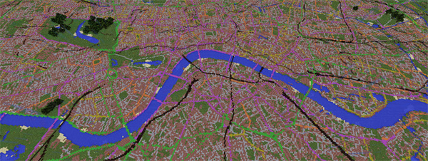
It proved a hit, with 100,000 downloads, and contributed to Braybook getting taken on as an employee. He’s now updated the map to cover 83 billion blocks, each of which covers an area equivalent to 25 meters by 25 meters and 12 meters tall. Once he’d figured out how to convert the Ordnance Survey data, the automated process took seven hours on a desktop PC.
The Minecraft map uses 10 game materials to represent real-world features: four colors of wool plus stone slabs correspond to five categories of road; water is a straight match; trees and grass correspond to forest and “plains”; brick covers built up areas; and black clay is used for railways. The increase in resolution means the map now covers even small roads and tributaries to rivers.
The 23GB file is free to download as a 1GB zip archive. Players will start off at the location of the Ordnance Survey’s real world headquarters near Southampton. As Minecraft has its own location reference system, players wanting to go directly to a specific place from the real world (rather than exploring the Minecraft map) can either use a coordinate finder map on the Ordnance Survey map, or use a special tool that converts OS grid references to Minecraft location references.